Our January thaw will peak tomorrow (Saturday) with the mercury hitting around 60 degrees during the afternoon. On Sunday we will be about ten degrees cooler, then "Whoa!" Back to reality as we return to normal daytime highs in the lower 30s for the first part of next week.
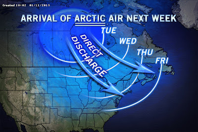 |
| (Courtesy of AccuWeather) |
OK, that's not so bad. But, wait till later next week. As you can see by the map above, a blast of pure arctic air will arrive during the day on Wednesday. By Thursday and for the next few days we could see temperatures only peaking around 20 with nighttime lows well down into the single digits. Yeah. That's more like winter. Brrrrrr!
At the moment, there don't appear to be any major snowstorms in our future, however with the arrival of the arctic air, we could perhaps crank up the Lake Erie snow machine again. We'll have to keep an eye on that.
So, enjoy the warm air this weekend. When the cold air arrives next week, it will likely hang around through the first couple of weeks of February.
- Bob


