|
Friday,
January 31
|
Mostly cloudy with occasional
light snow in the afternoon and evening with an inch or less accumulation by
Saturday morning.
High 33
|
|
At Night
|
Breezy with light snow.
Low 26
|
|
Saturday,
February 1
|
Cloudy with snow changing to rain
during the day. There could be a period of freezing rain during the
changeover. The rain will then change back to snow overnight. New snow
accumulations will be light.
High 42
|
|
Sunday,
February 2
|
A mix of clouds and sun and a bit
colder.
High 30
|
|
Monday,
February 3
|
Partly sunny.
High 23
|
Friday, January 31, 2014
Friday Forecast, January 31
Thursday, January 30, 2014
Thursday Forecast, January 30
|
Thursday,
January 30
|
Mostly sunny, breezy, and warmer,
but with some clouds later in the day.
High 28
|
|
At Night
|
Breezy with light snow
accumulating around an inch or less by morning.
Low 23
|
|
Friday,
January 31
|
Mostly cloudy with light snow
with an inch or so accumulation.
High 34
|
|
Saturday,
February 1
|
Cloudy with snow mixing with rain
during the day.
New snow accumulations 2-4 inches
by Sunday morning.
High 41
|
|
Sunday,
February 2
|
A mix of clouds and sun and a bit
colder.
High 27
|
Wednesday, January 29, 2014
Saturday: Snow? Rain? Mix?
One thing about the cold weather was that it was easy to predict. Now that the cold is moving on and snow systems are moving in, we will be getting into a messy period of trying to figure out what's going to happen.
Take for example this Saturday. After a couple days in the 30s, colder air is going to push back into northern Ohio. A storm system will move over Ohio during the weekend and produce snow? How much? Well that depends upon exactly where the system goes. Below are two different forecast models. While both show snow during the morning, the NAM shows rain over NE Ohio on Saturday afternoon. The GFS model shows snow continuing. Yeah...that's the problem. No rain = more snow. Rain = less snow. Right now I'm leaning more toward the mix...snow in the morning and later in the day with a period of rain in the middle. That may change, so keep checking back.
Take for example this Saturday. After a couple days in the 30s, colder air is going to push back into northern Ohio. A storm system will move over Ohio during the weekend and produce snow? How much? Well that depends upon exactly where the system goes. Below are two different forecast models. While both show snow during the morning, the NAM shows rain over NE Ohio on Saturday afternoon. The GFS model shows snow continuing. Yeah...that's the problem. No rain = more snow. Rain = less snow. Right now I'm leaning more toward the mix...snow in the morning and later in the day with a period of rain in the middle. That may change, so keep checking back.
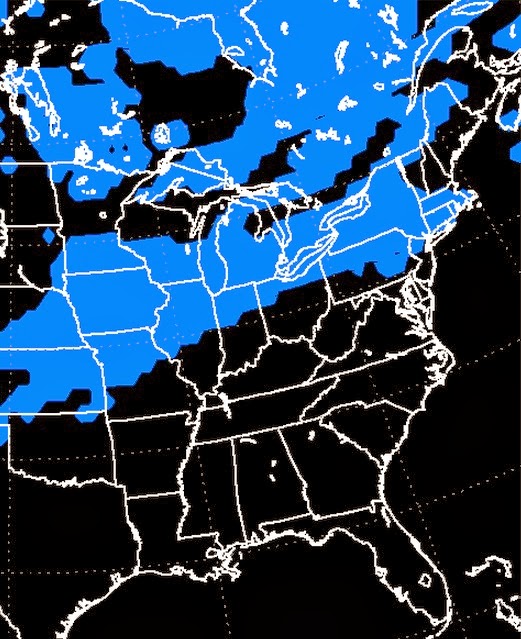 |
| GFS model shows SNOW over the area at 1pm Saturday |
 |
| The NAM shows RAIN over the area at 1pm Saturday |
You are already hearing talk about a possible snow storm the middle of next week. That's a good possibility as well. Similar to this weekend's storm is the uncertainty of the exact track of the system. Not so uncertain at this time is the fact that it will be snow instead of a mix of snow and rain. The question for next week's storm is just how much snow is going to fall across NE Ohio. We'll know more when we get a bit closer.
Like I said, the cold temperatures were a whole lot easier to predict.
Enjoy the sun and "warm".
Wednesday Forecast, January 29
FINALLY! A warmup begins today. Granted, a +14 isn't exactly a heat wave, but with the sunshine out there, I think this is going to be fine day. Enjoy!
|
Wednesday,
January 29
|
Lots of sun, but still cold. Breezy.
High 14
|
|
At Night
|
Mainly clear, but not as cold.
Low +6
|
|
Thursday,
January 30
|
Mostly sunny, breezy, and warmer,
but with some clouds later in the day and a bit of light snow overnight.
Morning wind chills around -5 to
-10, but then rapidly warming.
High 27
|
|
Friday,
January 31
|
Mostly cloudy with occasional
snow showers.
High 31
|
|
Saturday,
February 1
|
Cloudy with snow mixing with rain
at times during the day.
New snow accumulations 1-3 inches
by Sunday morning.
High 37
|
Tuesday, January 28, 2014
Frigid air to be replaced by snow
The frigid Arctic air that has been hanging over Ohio for much of January will soon be moving on. However, one ugly phase of winter will be replaced by another.
As the cold air moves out and milder and more closer-to-normal air moves in, the southern part of the U.S. is going to warm up as well. As we move through the first part of February, it looks like it's going to be a stormy period. The warm, moist air from the south will push northward over the cold air still in place over the Great Lakes. That's going to cause snow...and perhaps a lot of it. We could see some major snowstorms move through the Ohio Valley during the first few weeks of February.
We must have really angered Zeus. Sorry 'bout that, big guy. :-)
Tuesday Forecast, January 28
Temperatures today will barely get above freezing and wind chills won't be anywhere close to ZERO. Tonight will be just like this past overnight. Temperatures will drop to near or into the minus double digits and wind chills again will be in the -20s. On Wednesday afternoon we turn the corner and a warm-up begins.
|
Tuesday,
January 28
|
Mostly sunny and continued
extremely cold.
High around +3
Daytime wind
chill values -10 to -20
|
|
At Night
|
Mainly clear and frigid
Morning LOW
-10 to -15; wind chill values -25 to -30
|
|
Wednesday,
January 29
|
Lots of sun, but still cold.
High 13
|
|
Thursday,
January 30
|
Mostly sunny and warmer, but with
some clouds later in the day.
Morning wind
chills around -10, but then rapidly warming.
High 27
|
|
Friday,
January 31
|
Mostly cloudy
High 28
|
Monday, January 27, 2014
Monday Forecast, January 27
Here we go! Everything is right on track. At this hour (5am) western Ohio already has wind chills in the -10 to -15 range with actual air temperatures in the teens. It's coming!
However, if you want to feel better, just look at the Thursday morning forecast. The end is in sight. :-)
However, if you want to feel better, just look at the Thursday morning forecast. The end is in sight. :-)
Wind Chill ADVISORY
today!
Wind Chill WARNING
tonight through Wednesday morning!
|
Monday,
January 27
|
Cloudy, breezy, and turning
sharply colder during the day with flurries and snow showers.
Temperatures falling to below
ZERO in the evening with wind chill values dropping to -20.
|
|
At Night
|
Mostly cloudy, windy, and cold.
Morning LOW
-10; wind chill values -25 to -30
|
|
Tuesday,
January 28
|
Some clouds in the morning with
afternoon sun and continued very cold.
High around ZERO
Daytime wind
chill values -15 to -25
|
|
Wednesday,
January 29
|
Lots of sun, but still cold.
Morning LOW
-10 to -12; wind chill values -25
High 11
|
|
Thursday,
January 30
|
Mostly cloudy and warmer.
High 27
|
Sunday, January 26, 2014
Sunday Night Update
Cold air still heading this way and will arrive overnight and during the day tomorrow.

Happy anniversary to the Great Blizzard of 1978!
As we await the arrival of the coldest air mass of the winter this week, let it be noted that late January has often been cruel to Ohio.
Today is the anniversary of the worst blizzard in Ohio history. It began in the early morning of Thursday, January 26th. The storm blew up from the gulf and resulted in the lowest air pressure in the history of NE Ohio. Winds across the state topped 100mph. 75mph was the peak gust at Akron/Canton. Wind chills across the state reached -60. A total of 51 died in the storm.
On another note, this Tuesday (January 28th) will be the anniversary of the blizzard of 1977.
The good news is that we will get out of this mess as we head into February.
Sunday Forecast, January 26 ... Another Arctic Blast!
I will update things in more detail later today.
Another Arctic blast arrives tonight and stays through
Wednesday!
|
Sunday,
January 26
|
Cloudy and breezy with morning
flurries and snow showers followed by snow in the afternoon and evening.
High 27
|
|
At Night
|
Windy with snow accumulating an
inch or two by morning.
Low 11
|
|
Monday,
January 27
|
Cloudy, breezy, and turning
colder with flurries and snow showers.
Morning LOW
+11 wind chill values -5 to -10
An early morning high of 11 then
falling to below ZERO in the evening.
|
|
Tuesday,
January 28
|
Lots of clouds in the morning
with some afternoon sun and continued very cold.
Morning LOW
-10 to -15; wind chill values -25 to -30
High around ZERO
[Record LOW -13 in 1977]
|
|
Wednesday,
January 29
|
Lots of sun, but still cold.
Morning LOW
-10 to -15; wind chill values again -25 to -30
High 10
[Record LOW -13 in 1977]
|
Saturday, January 25, 2014
Saturday Forecast, January 25
Warmer weather is coming...but, not for another week. This coming week will feature another Arctic plunge. Woo hoo! (This is getting old...lol)
|
Saturday,
January 25
|
Cloudy and windy with snow continuing
into midday followed by snow showers in the afternoon and evening. New snow today
2-3.
High 23
|
|
At Night
|
Windy with snow showers and
blowing snow.
Low -1
Morning wind
chill values -15 to -20
|
|
Sunday,
January 26
|
Cloudy and breezy with morning
flurries and snow showers followed by snow in the afternoon and overnight
accumulating another 1-3 inches by Monday morning.
High 22
|
|
Monday,
January 27
|
Cloudy, breezy, and very cold
with flurries and snow showers.
Morning LOW
+10 wind chill values around -10
High 13
|
|
Tuesday,
January 28
|
Mostly cloudy and continued very
cold.
Morning LOW
-10 wind chill values -25 to -30
High around ZERO
|
|
Wednesday,
January 29
|
Lots of sun, but still cold.
Morning LOW
-10 wind chill values again -25 to -30
High 7
|
Friday, January 24, 2014
Friday Forecast, January 24
WIND CHILL ADVISORY
UNTIL 1pm FRIDAY!
WINTER WEATHER
ADVISORY OF WINDS AND BLOWING SNOW FRIDAY AFTERNOON THROUGH SATURDAY!
|
Friday,
January 24
|
A mix of clouds and sun. Windy.
High 15
|
|
At Night
|
Windy with snow and blowing snow.
Low 13
|
|
Saturday,
January 25
|
Cloudy and breezy with snow
continuing into midday followed by snow showers. Total new snow 3-5 inches by
evening.
High 23
|
|
Sunday,
January 26
|
Cloudy and breezy with morning
flurries and snow showers followed by snow in the afternoon and overnight accumulating
another 2-4 inches by Monday morning.
High 22
|
|
Monday,
January 27
|
Cloudy, breezy, and very cold
with flurries and snow showers.
High 12
|
WEATHER ALERT: Another
surge of Arctic air will drop over northern Ohio early next week with actual morning
air temperatures on Tuesday and Wednesday around -10 and wind chills in the -25
to-30 range.
Subscribe to:
Posts (Atom)